Current Station Location and Design
The current location and design of the Arcade Street Station and the Purple Line route through this area includes a new bus rapid transit station and guideway next to Neid Lane, just west of Arcade Street. The location and design, shown below, balances several tradeoffs in this area to provide fast, reliable, and accessible transit service. West of Arcade Street Station, buses will run in mixed-traffic on Neid Lane and Phalen Boulevard toward the Payne Avenue Station. East of Arcade Street Station, buses will run in a new bus-only roadway built north of Phalen Boulevard toward Cook Avenue Station. The Arcade Street Station will be at the same level as Neid Lane, then the bus-only roadway will run downhill toward the Bruce Vento Regional Trail corridor. The design includes a new trail connection between Neid Lane and the Bruce Vento Regional Trail.
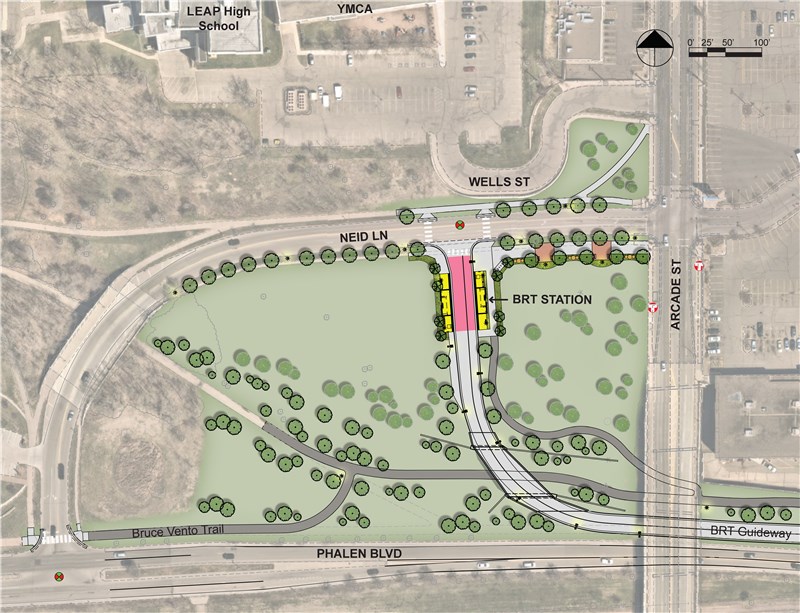
Plan view of the current Arcade Street Station location and design.
The concept renderings below illustrate the current design of the Arcade Street Station area.
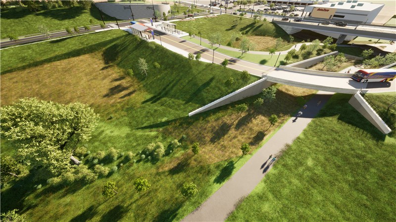
Bird’s eye view of the current Arcade Street Station location and design, looking northeast toward the station and the Arcade and Neid intersection.
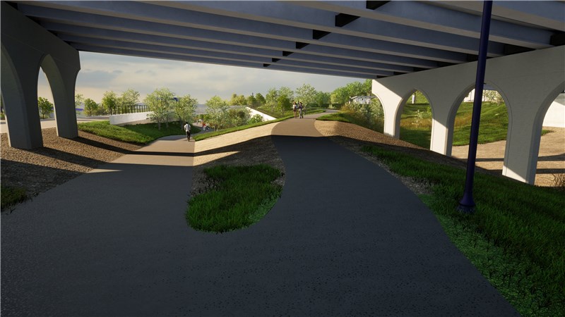
Street-level view from the Bruce Vento Regional Trail under the Arcade Street bridge, looing west toward the new trail connection to Arcade and Neid.
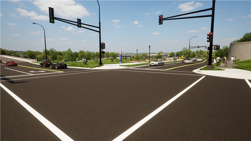
Street-level view from the Arcade and Neid intersection, looking southwest toward the Arcade Street Station.
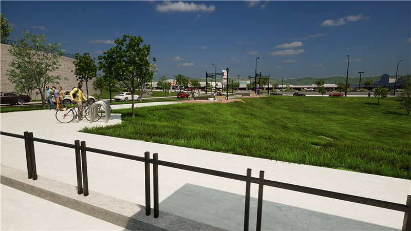
Street-level view from the Arcade Street Station, looking northeast toward the Arcade and Neid intersection.
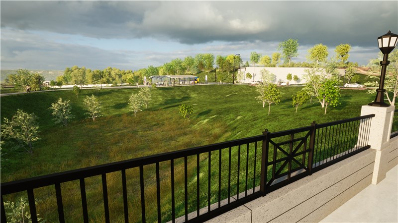
Street-level view from the Arcade Street bridge, looking northwest toward the Arcade Street Station
This location and design provides many benefits to the community identified during public engagement:
- It provides convenient access for people of all abilities. There are no steep slopes and is closer to points of interest than a station on Phalen Boulevard.
- It provides better proximity to destinations in the area than a station on Phalen Boulevard, including the Seeger Square shopping center, the YMCA, LEAP High School, and the nearby neighborhood.
- It encourages transit-oriented development on private and public property in the area.
- It provides better safety than a station on Phalen Boulevard through lighting, clear sight lines to the platform, and its proximity to Arcade Street.
History – Original Location & Design
In 2017, project decisionmakers recommended that the Purple Line route and the Arcade Street Station location run along Phalen Boulevard. Purple Line would stop at a new station level with Phalen Boulevard and a new building with a staircase and elevator would connect Arcade Street to the station. The design would provide fast and reliable transit service through this area and it could encourage development along Phalen Boulevard adjacent to the station.
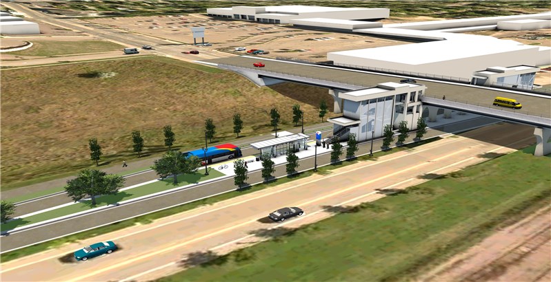
Bird’s eye view of the original Arcade Street Station on Phalen Boulevard, looking northeast toward the station and the Arcade and Neid intersection.
The project received feedback during 2018 station area planning efforts that encouraged staff to rethink the design.
This feedback led project staff to study alternative designs.
History – Creating A Direct Connection
During the environmental analysis phase of the project, between 2018 and 2021, staff studied alternative designs to provide a Purple Line station closer to the Arcade and Neid intersection. At that time, staff determined that the project should build a new bridge between Arcade Street and Phalen Boulevard that would create a direct connection for Purple Line buses. The design included a bus-only bridge and a Purple Line station on Neid Lane just west of Arcade Street. The Purple Line would run in mixed traffic on Neid Lane and Arcade Street. The Bruce Vento Regional Trail would run under the Arcade Bridge Street, like it does today. This station location and route design were included in the environmental assessment documentation that was approved by the federal government in October 2021. This provided approval for the project to build and receive federal funding for this design.
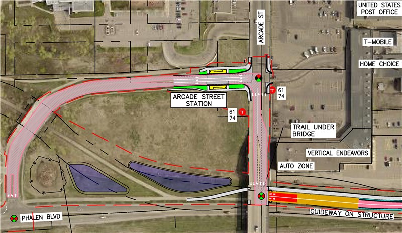
Plan view of the Arcade Street Station location and design developed during the environmental analysis phase.
However, public engagement after October 2021 indicated that the community wanted a new direct trail connection between the Bruce Vento Regional Trail and Arcade Street. The project decided to expand the width of the bridge to include a new trail, just north of the bus-only roadway (also called a guideway). To fit the expanded bridge, the project would also shift Phalen Boulevard to the south.
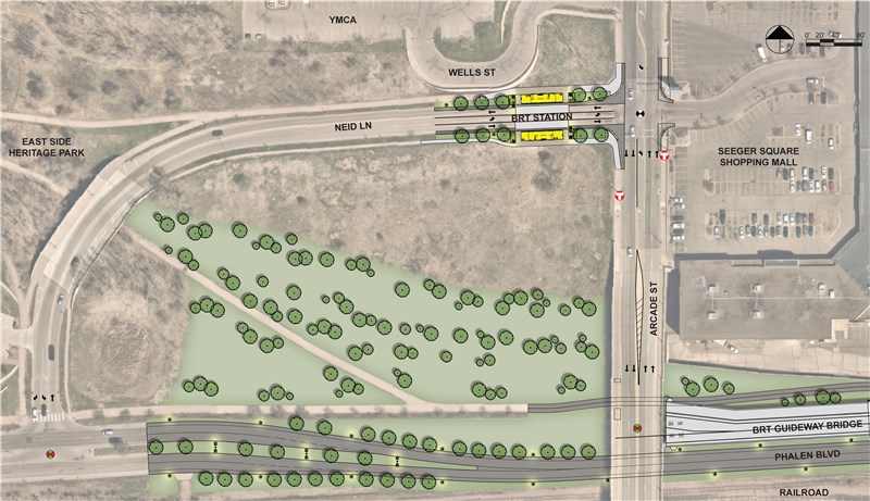
Plan view of the revised Arcade Street Station location and design developed in 2022 to include a new trail connection to Arcade street on the new bridge.
The community supported this new station design because of the proximity of the station to Arcade and Neid intersection and the new trail connection; however, project staff began to uncover several technical risks and concerns as staff designed the project throughout 2022. These risks and concerns include:
- There is large storm tunnel next to the location of the new bridge. Bridge construction could damage this tunnel and negatively impact the Arcade Street Bridge foundations and nearby retaining walls for Seegar Square.
- Station construction could damage the retaining wall holding up Wells Street.
- Adding a new trail connection to the new bridge would require the project to shift Phalen Boulevard south. Moving Phalen Boulevard would require additional soil contamination mitigation, utility relocation, and could negatively impact the nearby railroad.
- Cutting into the Arcade Street Bridge to attach a new bridge could damage the existing bridge beyond the limits of the project.
- The project would create a new signal in the middle of the bridge, creating a unique traffic pattern that many drivers may not know how to navigate.
- The slope of the new bridge required to fit within the space provided could create service disruptions during the winter when snow and ice make driving up the bridge difficult.
- The new bridge could be a large visual barrier between Phalen Boulevard and development east of Arcade.
All these risks and concerns reduced staff confidence of constructing the project within a specified budget and delivering a project that benefited the area.
History – Developing the Current Location & Design
Project staff worked to validate public support for the station location near Arcade and Neid through public engagement in the fall of 2022. Staff collected feedback about three station alternatives, illustrated below. Option A1 included the station near Neid and Arcade. Option B included a station near Phalen Boulevard, below Arcade Street, with a sloped pedestrian connection between Arcade Street and the station. Option C included a station farther east at the Wells and Phalen intersection. Hearing that the public continued to support Option A1, project staff developed Option A2 to blend community, cost, and technical considerations.
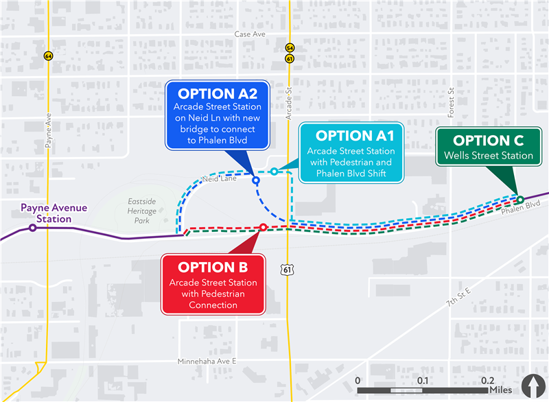
Map of the four Arcade Street Station location and route options studied in 2022.
The Purple Line Corridor Management Committee selected Option A2 as the preferred location and design in April 2023. It is the current location and design of the Arcade Street Station at the top of this page.
Next Steps
Project staff are working with the community to ensure the project provides the most benefit to the area. Design staff are continuing to advance the design of the current location reaching 30% design to refine technical and cost considerations. The project is working with project partners to determine if the project should add a new trail to better connect LEAP High School to Neid Lane and how best to accommodate plans to daylight the Lower Phalen Creek. The project is also conducting a market analysis of the area to determine the likelihood of transit-oriented development in the area, which could lead to an opportunity for an alternative station location and design. Project staff will provide timely updates on the design of the Arcade Street Station on this webpage.